| |


 Posts:
 19986
 Posted: Posted: Fri May 01, 2015 6:54 pm
OH NO.....not beautiful downtown Coalmont!! Not really much of a "town" but the area around it is full of history and great scenery. The only place in town which is open on a somewhat regular basis is the Coalmont hotel pub (the hotel is reputed to be haunted). Three stools at the bar and maybe 5 tables and the shuffleboard is about it, aside from the trophy heads and old mining and forestry implements hanging on the walls.  Coalmont Hotel the month before it opened on April 24, 1912. Coalmont Hotel the month before it opened on April 24, 1912.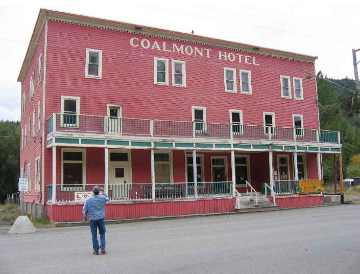 The hotel the way it looks today, and no that's not me drinking the beer! The hotel the way it looks today, and no that's not me drinking the beer!This is definitely one of those towns where if you blink you may miss it, it sits off the "main" road and the turn into town is easily missed.... 
|
Posted: Sat May 02, 2015 7:01 am
Wonder if you can use logging roads to get there from the Coquahalla summit? Would be an interesting drive.
|
Posts: 19986
Posted: Sat May 02, 2015 7:38 am
Canadian_Mind Canadian_Mind: Wonder if you can use logging roads to get there from the Coquahalla summit? Would be an interesting drive. Oh yeah, turn off the Coquihalla at the old toll booths, Coquihalla lakes, then head south on the Tulameen FSR which heads into the middle of nowhere, Jacobson Lake, or take the Lawless Creek FSR which will take you into Tulameen. The old Kettle Valley railroad runs all through this area also which still shows some of the old trestles and such. You might want to try panning on the Tulameen as it is one of the few places in Canada where you can find Platinum. Just be careful, a lot of the area is currently staked, the first warning sign maybe shots fired.....  
|
Posts: 35270
Posted: Sat May 02, 2015 7:45 am
Canadian_Mind Canadian_Mind: Wonder if you can use logging roads to get there from the Coquahalla summit? Would be an interesting drive. Much more interesting drive if there aren't any roads.
|
Posted: Sat May 02, 2015 3:19 pm
raydan raydan: Canadian_Mind Canadian_Mind: Wonder if you can use logging roads to get there from the Coquahalla summit? Would be an interesting drive. Much more interesting drive if there aren't any roads. Have you driven BC logging roads? Thanks Hyack. Another drive I'd like to try doing is the old Highway 1 routing up Highway 23. I've been told after Mika damn the old route got flooded, but google maps indicates a number of passable roads in the trench. Finding alternate routes through the mountains has become a bit of an interest of mine. It was spurred by a major accident outside Golden back in 2012. Traffic was backed up all the way to Salmon Arm. What was normally a 3 hour drive turned into 15 hours of ass pain with no obvious alternate route. Since then, I have always wondered if it was possible to use back roads and logging roads to traverse the Rockies, Kootenays, and Costal Mountains the same way you could use logging roads to get from Victoria to Port Hardy on the Island. Another route I'd like to find is a direct crossing from Valemount or McBride to Highway 97, rather than going all the way up to PG or down to Highway 24 (which I have yet to drive)
|
Posts: 35270
Posted: Sat May 02, 2015 3:33 pm
Canadian_Mind Canadian_Mind: Have you driven BC logging roads? Have you driven the Trans Labrador highway?  Actually, it's not too bad, if you like gravel... but some call it the loneliest road in the world... and it's over 1200km long.  
|
Posts: 19986
Posted: Sat May 02, 2015 3:53 pm
Canadian_Mind Canadian_Mind:
Have you driven BC logging roads?
Only since the middle 70's......Van Island, the Kootenays west, all through the Okanagan and Cariboo south of Willie's puddle, Barkerville south, everywhere around the Lower Mainland, Fraser valley and canyon, Manning Park, Merritt-Princeton-Hope.....
|
Posted: Sat May 02, 2015 4:27 pm
Hyack Hyack: Canadian_Mind Canadian_Mind:
Have you driven BC logging roads?
Only since the middle 70's......Van Island, the Kootenays west, all through the Okanagan and Cariboo south of Willie's puddle, Barkerville south, everywhere around the Lower Mainland, Fraser valley and canyon, Manning Park, Merritt-Princeton-Hope..... That question was directed at Raydan.
|
Posts: 13404
Posted: Sat May 02, 2015 4:33 pm
turn off the Coquihalla at the old toll booths, Coquihalla lakes, then head south on the Tulameen FSR which heads into the middle of nowhere, Jacobson Lake, or take the Lawless Creek FSR which will take you into Tulameen. The old Kettle Valley railroad runs all through this area also which still shows some of the old trestles and such.
... sounds like the native homeland of the Fukawwe tribe.
|
Posts: 19986
Posted: Sat May 02, 2015 4:50 pm
Canadian_Mind Canadian_Mind:
That question was directed at Raydan.
I knew that but..... Jabberwalker Jabberwalker:
... sounds like the native homeland of the Fukawwe tribe.
I've ran into members of that tribe from one end of the province to the other....  Usually coming out of a pub at closing time....
|
Posts: 11829
Posted: Sat May 02, 2015 7:01 pm
If you're in McBride you're already at Hwy16 to Prince George. That's an interesting lonely drive that one. Hwy 24 is a nice detour as well.
Used both several times, just to end the boredom of driving 97. Wish there was a Coquihalla Connector on our side, its such a bother we usually drive the canyon.
Go to a Forestry office and buy some maps, but check first. They've deactivated some roads, taken out bridges, etc.
We used to do a lot of exploring in the early 70s dune buggy & Power Wagon days.
|
Posts: 19986
Posted: Tue May 05, 2015 12:07 pm
I've never driven the Trans Labrador highway but I have done the Southern Yellowhead highway (Hwy 5) from Kamloops to McBride and then the Yellowhead highway (Hwy 16) itself through to Edmonton. Although the whole route was paved, unlike the Trans Labrador, this was one of the most desolated roads I've ever traveled! Miles and miles of nothing but miles and miles, no gas stops, cafes or lodging of any sort. The scenery was of course fantastic! The only other route in B.C. which I could compare it to for desolation and scenery would be the unpaved Stewart-Cassiar / Dease Lake Highway (Hwy 37) running from Kitwanga to the Alaskan Highway in the Yukon Territories. As for Hwy 24, I've never driven the paved route but did spend time up there in the '70s and '80s when it was the Sheridan/Bridge lake road, Miles and miles of nothing but lake after lake with great fishing everywhere!
|
Posted: Tue May 05, 2015 1:47 pm
I heard the trip to Bella Coola is pretty rough. Generally the 5 has a town once every 100km or so... no promise the fuel station will be open though.
|
Posts: 19986
Posted: Tue May 05, 2015 2:28 pm
Canadian_Mind Canadian_Mind: I heard the trip to Bella Coola is pretty rough. Generally the 5 has a town once every 100km or so... no promise the fuel station will be open though. The Chilcotin-Bella Coola highway (Hwy 20) A bunch of us made the trip from William's Lake to Anahim Lake/Tweedsmuir Park years ago for a weeks worth of hunting. The road, while just about all gravel was decent enough, and as usual for BC the scenery was fantastic. We never made it to Bella Coola although we did do "the Hill" down to the Bella Coola river for some great fishing. It was a decent trip with us bagging two moose, a couple nice Coho salmon and loads of trout, which was great as one of the guys wife prepared a whole shitload of food for us......poor bastard....his wife couldn't cook worth shit....
|
 
|
Page 1 of 2
|
[ 27 posts ] |
Who is online |
Users browsing this forum: No registered users and 24 guests |
|
|


") Site Admin
Site Admin